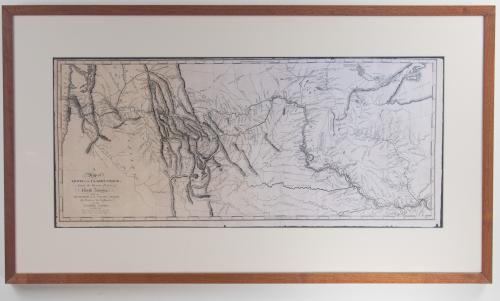
Reproduction of A Map of Lewis and Clark's Track, Across the Western Portion of North America From the Mississippi to the Pacific Ocean; By Order of the Executive of the United States, in 1804, 5 and 6.
This reproduction depicts the original map and the written account of the expedition by Lewis and Clark that completely changed the American mapping of the Northwest. The cartographic rendering provides the first accurate depiction of the relationship of the sources of the Missouri, the sources of the Columbia, and the Rocky Mountains. The map was copied by Samuel Lewis from William Clark's original drawing and was later engraved by Samuel Harrison. The map appeared in Lewis and Clark's "History Of The Expedition UnderThe Command Of Captains Lewis And Clark." The depiction of this map details an uncolored map highlighting the topography and rivers in the region as well as towns, Indian villages, and population figures.