KCQ: rapid response: Quick answers to your Kansas City history questions

“What’s your KC Q” is a joint project of the Kansas City Public Library and The Kansas City Star. Readers submit questions, the public votes on which questions to answer, and our team of librarians and reporters dig deep to uncover the answers.
Have a question you want to ask? Submit it now »
by Missouri Valley Special Collections Staff
For this installment of “What’s Your KCQ?,” the joint project of the Kansas City Public Library and The Kansas City Star, Missouri Valley Special Collections staff tackle a variety of Kansas City history questions.
What’s the small projection on the north side of Commerce Tower near the top of the building?
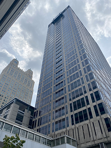
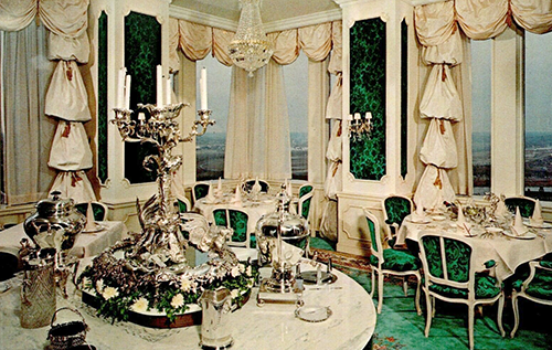
When Commerce Tower at 911 Main Street opened in 1964, one of the modern office building’s many amenities was the Top of the Tower restaurant on the 30th floor. Rather than a single dining experience, Top of the Tower offered diners five distinct experiences: the Mongolian-themed Genghis Khan, the Irish-themed Paddy’s Pub, the Italian-themed Guiseppe’s Roof, the German-themed Salzberg Haus, and the French-themed Tour d’Argent. An advertisement from the building’s opening promised diners “an unparalleled view of Kansas City’s surging skyline and the countryside beyond,” and with the 180-degree view south toward the river made possible by the small projection, the statement rang true.
Top of the Tower closed in 1975. Ten years later, Commerce Trust Company moved out of the building. Vacancies increased as downtown went into decline. Finally, in 2013, the property was acquired by an investment group who rehabilitated the structure into residential units for new city dwellers. Today, the small projection on the 30th floor is part of an apartment inhabited by a very lucky someone with a spectacular view.
How did the various lakes like Tapawingo, Lotawana, and Jacomo in Jackson County get their names?
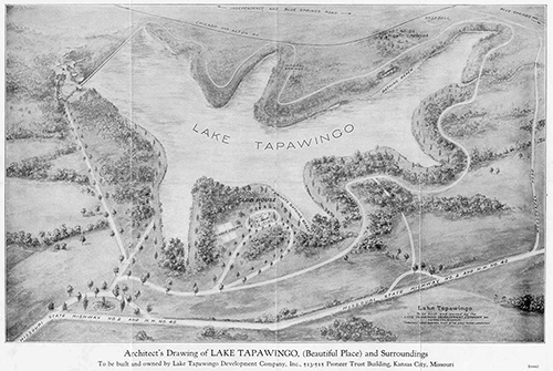
Milton Thompson, real estate investor and owner of Highland Farms, led the development of Lake Tapawingo in 1926. Tapawingo, which translates to “beautiful place” in the Sioux language, was advertised in The Kansas City Star as the city’s “exclusive sports retreat and rest haven.” Businessmen looking for summer homes quickly bought up the five hundred picturesque lots surrounding the lake.
Shortly after Tapawingo’s success, Thompson and his associates embarked upon a second lake project in the Sni-A-Bar Creek valley, Lake Lotawana. According to Thompson’s wife Maud, a group of the developers’ wives chose the name during a political rally, specifying that it should be pronounced with a long O sound. Lotawana or Lotowana, meaning “sparkling water,” was the name of a legendary Mohawk princess from the Catskill Mountains.
The etymology of the 970-acre Lake Jacomo is perhaps less exciting. Named by the county court in 1958, “Jacomo” is an acronym for Jackson County, Missouri (JA-CO-MO.) According to The Star, the descriptive name was used to specify that the recreational district was financed solely by the county, without state or federal funding. Planning for Lake Jacomo began in the early 1950s due to increasing demand for more recreational areas in Jackson County.
How did Coal Mine Road get its name?
One reader noticed a short stretch of street named Coal Mine Road near the Blue River and Eastwood Park and wondered if it was named for an actual coal mine. Not only was there a mine in the area, but also a now forgotten town that trusted its future to the mine’s success. Both were short-lived.
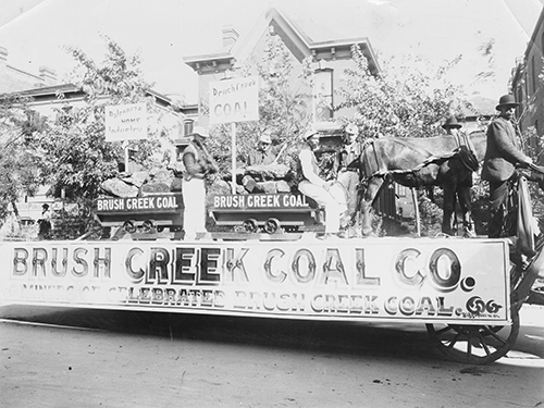
In the early 1880s, geologist John A. Gallaher found traces of a coal bed along Brush Creek. At the same time, real estate developer George W. Neumer settled near the find. Gallaher and a group of investors sank a coal shaft along Brush Creek about one and a half miles south of Leeds and started mining as the Kansas City Clay and Coal Company. While observing the progress of the mine, Neumer dreamed of establishing a town to capitalize on its success. He bought up land around 43rd Street and Indiana Avenue and named the area Cedar Springs.
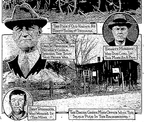
The company didn’t last long, though. Due to poor ventilation in the mines and Gallaher missing a payday, his workers went on strike and came close to hanging him in 1894. The mine closed and its property and assets were sold off later that year. Consequently, Cedar Springs became a ghost town and faded from memory. By 1900, the mine reopened as the Brush Creek Coal Mining Company. Continued poor management and working conditions caused the mine to be closed permanently shortly thereafter.
In 1916, a Kansas City Star article reported that a delegation of area farmers had asked the city to grade what had become known as Coal Mine Road, described at the time as one of the oldest roads in Jackson County.
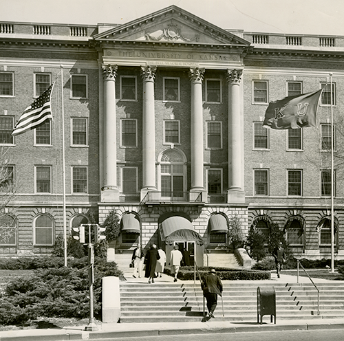
Who was Bell Memorial Hospital on the KU Medical Center grounds named for?
Bell Memorial Hospital near West 39th Avenue and Rainbow Boulevard, now known as the Murphy Administration Building of the Kansas University Medical Center, was named in honor of one of Rosedale’s original power couples.
Simeon B. Bell was born in New Jersey in 1820. His family relocated to Ohio, where he was raised, courted his wife Eleanor Taylor, and graduated from medical school in 1852. Hoping to expand his medical practice in the west, the Bells came to the Kansas Territory in 1857. Their timing couldn’t have been worse.
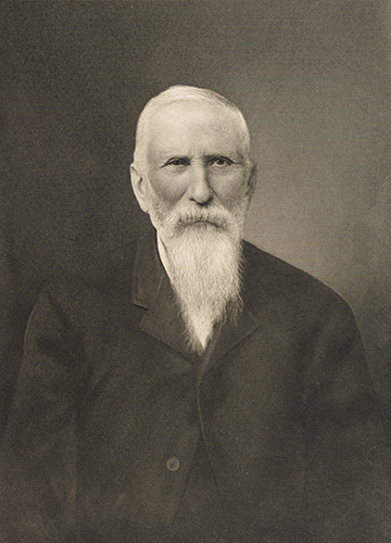
In the late 1850s, future Kansans and Missourians living on the state’s western border fought bitterly over the extension of slavery into the territory, and the Bells were unable to avoid the conflict. Settling in Johnson County near modern day Stillwell, the abolitionist Bells saw their home burned by pro-slavery border ruffians. During the Civil War, Bell served as a field doctor for Union forces in the area.
After the war, the Bells moved north to the town of Rosedale, where Dr. Bell became a respected landowner, school board member, and philanthropist. Sadly, however, Eleanor passed away in 1866.
In 1905, Dr. Bell made a generous donation to the University of Kansas – 101 lots of land and money to build a hospital and medical school in Rosedale. His only stipulation was that it be named in honor of his late wife. The Eleanor Taylor Bell Memorial Hospital was situated on a rocky bluff above Southwest and Rainbow boulevards in an area once known to locals as Goat Hill.
Interestingly, Bell was also responsible for the development of Southwest Boulevard, donating land and money to better connect Kansas City to Rosedale and other towns to the southwest. Bell died in 1913 and was interred alongside Eleanor in Silent City Cemetery in DeSoto, Kansas.
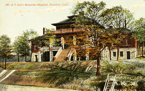
Staff of the Eleanor Taylor Bell Memorial Hospital trained future medical professionals from 1907 through 1924, when the hospital and school moved to the present-day building. The new facility was renamed simply Bell Memorial Hospital to honor both Eleanor Taylor and Dr. Bell.
The old building on Goat Hill served a variety of functions over the years. It housed the medical school’s museum, hosted Boy Scouts meetings, and was used to house tuberculosis and psychiatric patients. Later, from 1958 to 1970, it was occupied by 300 monkeys used for a viral research project funded by the National Institutes of Health. The building’s usefulness at an end, it was finally torn down in 1972. Today, the Rosedale Arch stands near its former site.
Where was the observatory that used to be in Swope Park located?

From a Junior Astronomy Club flyer, 1966. | Kansas City Parks & Recreation Department
Between 1965 and 1983, there was indeed an observatory in Swope Park just north of Camp Lake of the Woods. The structure was built by the Parks and Recreation Department and primarily operated by the Kansas City Astronomy Club (now known as the Astronomical Society of Kansas City). The 18-by-20-foot building featured a rolling roof made of green plastic and plywood, which covered and uncovered a 16-inch diameter telescope. Viewing parties, demonstrations, and workshops were held regularly for the public as well as attendees of the park’s Camp Lake of the Woods and Camp Hope.
In 1983, the telescope was removed and the club moved to Powell Observatory in Louisburg, Kansas, where the nighttime skies were darker. A newspaper article from the time suggested the former observatory might be converted to a bird blind. But the Parks Department was not able to confirm if it was, in fact, repurposed.
The fate of the building is unclear. Today, that area hosts a Parks Department residence and a few small, older buildings. If the structure is still standing, it has been reconfigured and the green rolling roof is no more.
Submit a Question
Do you want to ask a question for a future voting round? Kansas City Star reporters and Kansas City Public Library researchers will investigate the question and explain how we got the answer. Enter it below to get started.